|
OLD DEVONPORT
. UK |
||
|
© Brian
Moseley, Plymouth Webpage created: March 16, 2017. Webpage updated: January 12, 2019 |
||
|
|
||
|
ROADS AND STREETS IN OLD DEVONPORT MORICE SQUARE (TOWN SQUARE)
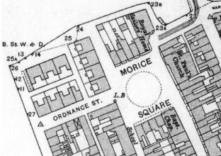
Morice Square showing its principal buildings
and the tram terminus. The Saint Aubyn Estate Rental Books held by the Plymouth and West Devon Record Office in accession number 387 for the period from circa 1729 until 1860 include references to properties in Town Square. It had become Morice Square, though, by 1765, as shown on Benjamin Donn's map of Plymouth-Dock. In 1914 the numbering of Morice Square started at the Royal Naval and Military Free Schools, which were both number 20 King Street and number 1 Morice Square. This was purely due to the School having taken over the property that originally formed number 1. There were then three more properties before the junction with Ordnance Street. Corporation Dwellings ran down to the Gun Wharf Wall. Numbers 8 to 12 then formed the north-western side of the Square, including the Royal Sailors' Home, later the Royal Fleet Club. The Anglican Church of Saint Paul formed most of the eastern side of the Square, while the Morice Square Baptist Chapel was the principal building on the south-eastern side. Tram services operated by the Devonport and District Tramways Company to Tor Lane via Saint Levan Road and Saltash Passage via Camel's Head terminated off the north-eastern side of the Square although the terminus itself was known as Morice Square. When the tramway services were replaced by motor buses, they travelled up King Street, around Morice Square and stopped at the former tram stop before either going down New Passage Hill or back down Marlborough Street to Fore Street.
|
||
|
|
|
|