|
OLD DEVONPORT
. UK |
||
|
© Brian
Moseley, Plymouth Webpage created: February 07, 2016. Webpage updated: May 17, 2019 |
||
|
|
||
|
FREDERICK SQUARE BARRACKS
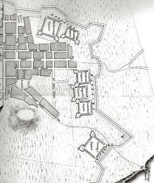
Frederick Square Barracks was the top-most of the block of three barrack squares shown in the above extract from Benjamin Donn's map of Plymouth-Dock made in 1765. Its most northerly wall was in line with Back Street, later Cherry Garden Street. Like its neighbours it was constructed of single-storey buildings within "The Lines" in 1757. The two blocks to its immediate south were Ligonier Square and Cumberland Square. It was occupied by the Royal Engineers and artificers.
|
||
|
|
|
|